In most parts of the country, the term “lake-effect” has little meaning. But there are a few places where this hyphenated adjective carries with it a sense of foreboding. That’s because lake-effect snow, particularly robust and prolific snow showers, are capable of dumping several feet of snow on the cities and town in their path. Several factors — geography, topography, atmospheric temperatures, wind trajectories — come into play to create the perfect storm of lake-effect weather phenomenon.
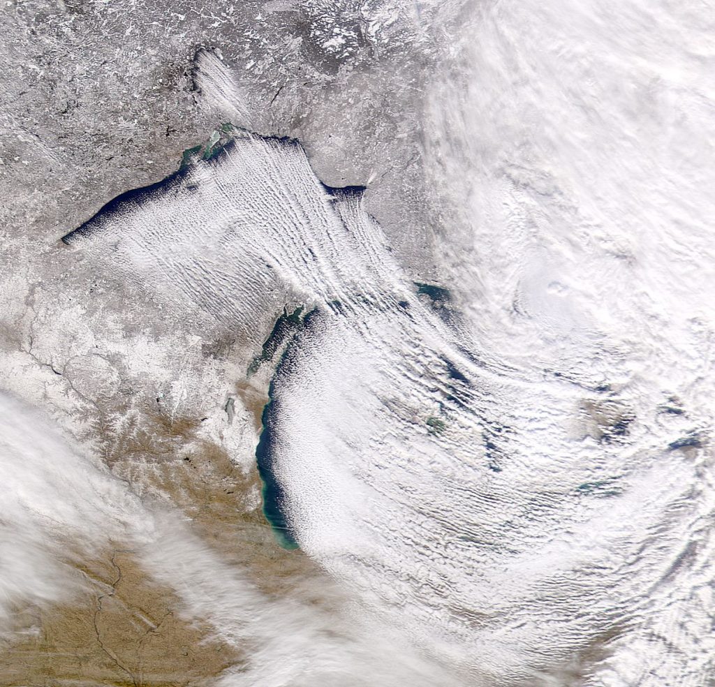
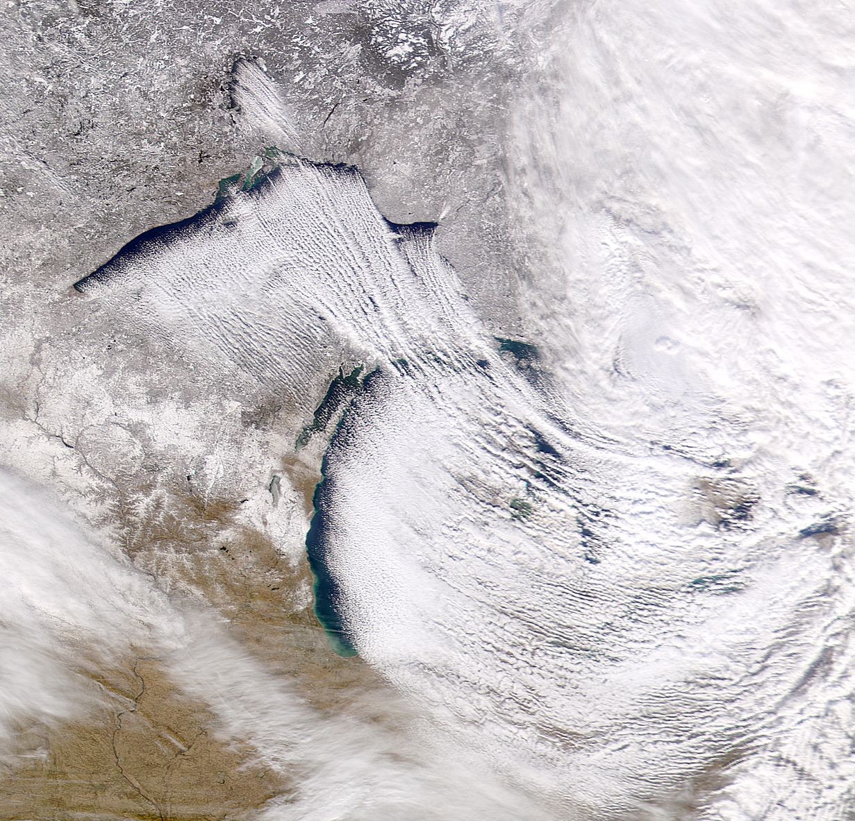
Lake-effect snow needs a few key components for optimal snow production. As the name implies, the first thing that is needs is a lake. Not just any lake either. It needs to be a lake of considerable size and greatness…the Great Lakes, for instance. The lake needs to be large enough to allow the storm plenty of time to pick up moisture as it passes over. Covering more than 94,000-square miles, the Great Lakes provide the perfect fuel for the lake-effect phenomenon.
Where the Great Lakes are located, geographically, is also a factor that increases the opportunity for lake-effect snow. Just upwind of the Great Lakes is Canada’s Hudson Bay, another really large body of water. Arctic air masses absorb moisture from the Hudson Bay, and then top off over the Great Lakes, so they are at maximum power.
The arctic air mass is another key ingredient to the lake-effect phenomenon. The air temperature at 5,000-feet must be colder than the lake temperature, at least 23-degrees Fahrenheit colder, in fact; otherwise the storm cannot absorb enough moisture and heat from the lake to start the lake-effect snows.
Yet another important factor in the creation of lake-effect snow is wind, specifically the speed and direction of the wind. If the winds are slower, the lake-effect snow will fall at or near the shoreline, but if the winds are stronger, the snow will hit inland. Ideally, the wind should be blowing in the same direction throughout the lower atmosphere. When the winds are aligned with the longest axis of the lake, the heaviest snow bands are formed. This happens because the storm has a maximum path, or fetch, over the water, giving it maximum time to pick up heat and moisture. Since each one of the Great Lakes is oriented differently, the optimal fetch for each one also differs, as this chart indicates:
Lake Superior: Northwest, north or northeast
Lake Michigan: North to north-northeast
Lake Huron: North-northwest
Lake Ontario: West
Lake Erie: Southwest
Sometimes two or more Great Lakes add to a fetch. A northwest wind could blow over Lake Superior, Lake Huron, and Lake Ontario, creating lake-effect snow on the southeast sides of each of these lakes.
The storm needs the open water of the Great Lakes for it fuel. Once the lake freezes over, the heat and moisture source is lost. Without this key component, lake-effect snow cannot be produced. Therefore, lake-effect snow is more common in early to mid-winter, before the lakes have time to freeze over. Lake Ontario, however, is the deepest of the Great Lakes and typically does not completely freeze over like the other lakes do. As a result, the lake-effect snow season can last all winter long.
It is the lake-effect phenomenon that is responsible for the news-worthy reports of massive snowfalls that hit the communities located downwind of a Great Lake, cities like Buffalo, New York, Grand Rapids, Michigan, Syracuse, New York, South Bend, Indiana, Cleveland, Ohio, and Rochester, New York. In 1966, Copenhagen, New York, received a foot of lake-effect snow in just one hour, and a neighboring town, Montague, New York, got 40 inches of lake-effect snow in a twenty-hour period in 1997.
While these are staggering amounts, this kind of snowfall is not an everyday occurrence. In order to activate the lake-effect snow phenomenon, the right combination of geography, temperature, wind direction, and a really big body of water are needed to create the perfect storm that is lake-effect snow.
Sources
Donegan, Brian. “What is Lake-Effect Snow?” The Weather Channel. N.p. 11 Nov. 2016. 10 Feb. 2017.
Torregrossa, Mark. “Here’s How Michigan’s Lake Effect Snow Machine Works.” MLive.com. N.p. 02 Dec. 2016. Web. 12 Feb. 2017.